|

|
|
|
Last Updated: Feb 6, 2017 - 2:32:04 PM |
Chantal to Reach Bahamas, Florida Waters by This Weekend
By Alex Sosnowski, Expert Senior Meteorologist for AccuWeather.com
Jul 10, 2013 - 11:48:57 AM
|
Email this article
Mobile friendly page
|
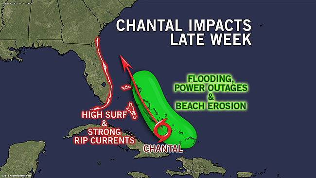
State College, Pa. -- 10 July 2013-- AccuWeather.com reports Chantal, or its ghost will cruise the Bahamas and waters just east of Florida by this weekend with rough surf, building seas, torrential downpours and gusty squalls.
After bringing the potential for flooding rain and mudslides to portions of Hispaniola and Puerto Rico at midweek, AccuWeather.com Hurricane Center meteorologists expect Chantal to turn more to the northwest late this week and weekend.
Chantal was struggling to survive as it approached Hispaniola Wednesday, but a zone of showers and gusty squalls associated with the system is expected to move north of the island and its rugged mountains later this week.
Travel, beach and boating interests in the Turks and Caicos Islands, The Bahamas and the southeastern coast of United States should continue to monitor the progress of Chantal.
While Chantal is forecast to spend much of its life as a tropical storm to perhaps a Category 1 hurricane, rough surf and building seas will affect the islands in the region and beaches from the Florida East Coast to areas as far north as the Carolinas into this weekend.
The exact track and intensity of Chantal beyond the Bahamas is a bit uncertain at this time with possibilities ranging from the system dissolving to regaining strength after crossing Hispaniola.
Even if Chantal fails to recover from the venture around the high mountains of Hispaniola Wednesday into Thursday, a zone of torrential downpours and locally strong thunderstorms would be strewn over the region, due to a persistent flow of tropical moisture from the Caribbean.
The moisture alone brings the potential for flash and urban flooding to Florida to the southeastern part of the mainland United States.
While steering winds will be weak around the southeastern U.S. into early next week, a general drift of the system and its moisture toward the northwest is most likely. Chantal or a remnant thereof could drift toward the U.S. as a result.
The tropical moisture, with or without Chantal, is likely to linger from the Carolinas to Georgia and Florida next week in the form of downpours, locally strong thunderstorms and a risk of localized flooding.

© Copyright 2013 by thebahamasweekly.com
Top of Page
|
|
|
|